Southern California is preparing for a powerful storm system during Christmas week. Weather officials warn that an atmospheric river will bring heavy rain, rapid flooding, and travel disruptions from Christmas Eve through Friday. Holiday travelers should expect delays on highways, mountain passes, and in some airport corridors as conditions shift hour by hour.
Storm System Strengthens Across the Region
Meteorologists expect the most intense rainfall from late Tuesday through Christmas Eve. Several inches of rain may fall in foothill zones, coastal hillsides, and communities near burn scars. These locations face the highest risk of debris flows and flash flooding. The National Weather Service has issued flood watches and flash flood warnings for a wide swath of Southern California, including Los Angeles County foothills, Antelope Valley, Ventura County, and parts of Santa Barbara County.
Short bursts of thunderstorms may also develop inside the storm band. These localized cells can produce sudden downpours, dangerous lightning, and gusty winds. Forecasters stress that conditions can deteriorate quickly, especially in canyons and low-lying streets.
Heavy Rainfall Expected Through Friday
The storm’s long duration poses added difficulty for travelers. Rainfall is projected to continue well into Thursday and Friday. While showers taper heading into the weekend, saturated soil and full drainage systems will keep residual flood hazards elevated. Travelers planning post-holiday trips should remain cautious, especially near areas that flood regularly after major storms.
Wind Advisories and Thunderstorm Risks
Moderate to strong winds may push across mountain ridges and open corridors. These gusts may cause fallen branches, reduced visibility, and challenging driving for high-profile vehicles. Thunderstorm chances remain scattered but real, especially during peak moisture surges. Officials urge drivers not to underestimate fast-moving cells, which can bring brief but severe conditions.
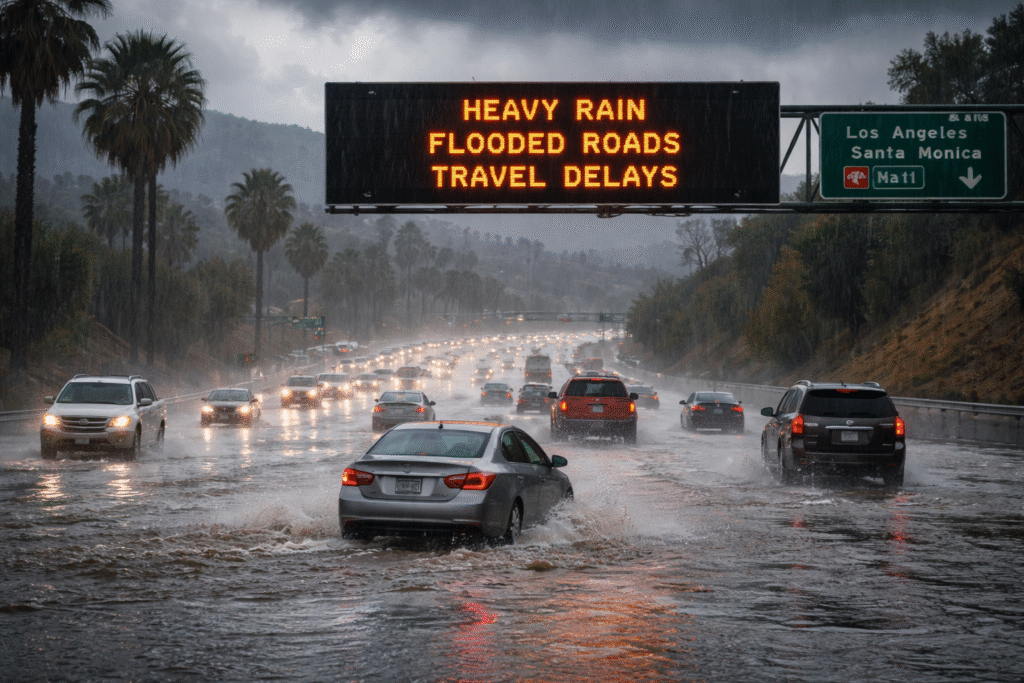
Road Conditions: Major Impacts for Holiday Travel
Holiday tourism is especially vulnerable during this weather pattern. Many popular routes may face closures or delays due to flooding, debris, or poor visibility.
Road Flooding
Some highways and city roads may turn impassable. Even shallow water can lift a vehicle or conceal washed-out pavement.
Flash Flood Hazards
Rapid rises in water are expected in creeks, washes, and underpasses. Flash floods happen with little warning, particularly at night when visibility is low.
Debris Flow Risk
Burn scar areas remain a top concern. These regions can release mud, rocks, and tree limbs without notice during intense rain bursts.
Traffic and Congestion
Slower speeds are likely across major freeways. Motorists should expect longer travel times and increased stress on alternate routes.
Airport Travel
Storms may bring delays to flights, especially during heavy rain periods. Airport travelers should allow extra time and stay alert for schedule changes.
State Safety Guidance for Drivers and Tourists
California transportation and emergency agencies urge travelers to monitor real-time conditions. The state emphasizes preparedness, especially for visitors unfamiliar with local flood-prone routes.
Before Traveling
- Review active flood warnings across your route.
- Check highway conditions for closures, detours, and chain requirements in mountain areas.
- Avoid travel during the storm’s peak period, especially Christmas Eve and early Christmas Day.
During Travel
- Never attempt to drive through flooded roads. Even a few inches of moving water can disable a vehicle.
- Keep headlights on at all times during heavy rain.
- Slow down, increase following distance, and avoid sudden braking.
- Watch for rockslides along canyon and mountain roads.
If Weather Conditions Worsen
- Seek safe shelter and wait for updated announcements.
- Follow directions from emergency crews and road authorities.
- Move to higher ground if flooding threatens low-lying roads.
Local Forecast Snapshot: Inland Empire and Surrounding Areas
Communities across the Inland Empire, including Corona and nearby corridors, will see repeated rounds of showers and possible thunderstorms. Flood watches and wind advisories remain in place through at least early Thursday. Rain continues into late week, though intensity should gradually decrease as the storm moves east.
Why Timing Matters for Holiday Travelers
The Christmas storm’s impact may vary by day, giving travelers a chance to adjust plans. Early planning is key. Those traveling after the strongest rainfall—late Saturday and beyond—may face fewer hazards. However, mountain regions may still see runoff, slick roads, and lingering debris.
Advantages of Early Weather Alerts
Tourists benefit from early public forecasts and road condition updates. These resources help avoid the most dangerous travel windows. Many visitors to Southern California may not realize how quickly flash floods form or how rapidly a canyon road can fill with debris. Official guidance gives travelers a vital head start in preparing a safer route.
Disadvantages for On-the-Road Travelers
The primary challenge is the unpredictable nature of intense storms. Roads can close without warning. Detours may stretch travel times significantly. Wet conditions also reduce traction, increasing accident risk. For tourists, this can disrupt itineraries, outdoor plans, and family visits.
Final Outlook for Christmas Week Tourism
Southern California will face a significant storm event during Christmas week, marked by heavy rain, strong winds, and dangerous flooding. Travelers should remain flexible, stay alert to weather advisories, and allow extra time for all holiday journeys. The combination of early warnings, road condition updates, and thoughtful planning can help ensure a safer holiday travel experience across the region.
For more travel news like this, keep reading Global Travel Wire