The UK Met Office has issued a yellow weather warning across large parts of England, Scotland, and Wales as a powerful summer storm is expected to bring torrential rain, thunderstorms, and gusty winds from 6:00 AM on Friday, July 4, until 3:00 PM on Saturday, July 5, 2025. The volatile weather is set to disrupt weekend travel plans and pose significant safety concerns for both residents and visitors across the affected regions.
As the UK continues its pattern of unpredictable summer weather, the Met Office urges travelers, tourists, and locals to take necessary precautions, especially if they plan to travel or engage in outdoor activities during the weekend. The most heavily impacted areas include Western Scotland, Central and Southern England, and South Wales, where rainfall is expected to be heaviest and flooding risk most severe.
What to Expect: UK Summer Storm Forecast Highlights
The Met Office outlines multiple severe weather risks over the next 48 hours:
1. Heavy Rainfall and Flooding
Forecast models predict 40–60 mm of rainfall within a few hours, with up to 100 mm possible in Scottish highland regions. Urban areas like London, Oxford, and Cardiff face surface flooding risks due to overwhelmed drainage systems. The Environment Agency has advised residents in flood-prone areas to monitor local alerts via the Flood Warning Information Service.
2. Thunderstorms and Lightning
Intense afternoon thunderstorms are expected to bring lightning strikes, hailstorms, and short bursts of extreme rainfall. The Met Office has warned of power outages and damage to buildings and trees, especially in open and coastal areas.
3. Strong Wind Gusts
Wind speeds could reach 40–50 mph, particularly across hilly terrain and coastal zones. These gusts pose a risk to high-sided vehicles and may lead to treefall, flying debris, and structural damage.
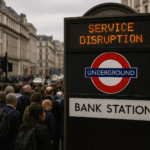
4. Severe Travel Disruptions
Flooded roads and limited visibility will create hazardous driving conditions. The UK’s National Highways Agency has advised against non-essential travel. Public transport is also expected to be heavily affected:
- Train services may be delayed or cancelled due to flooded tracks or fallen trees.
- Bus routes in low-lying areas could be suspended.
- Air travel at regional airports like Birmingham, Heathrow, and Edinburgh may face schedule disruptions due to ground delays and reduced visibility.
Regional Weather Breakdown
Scotland
Western regions like Perth and Kinross, Argyll and Bute, and Inverclyde will be among the worst hit. Rivers such as the River Tay and Clyde are expected to rise rapidly. Motorists should exercise extreme caution on rural and mountain roads.
Wales
South Wales—including Cardiff, Swansea, and nearby valleys—will see sustained downpours, particularly on Friday afternoon. Emergency services in Wales are on alert, and travelers are urged to check Traffic Wales for real-time updates.
England
Central and southern England—including major hubs such as London, Oxford, and Birmingham—will face intense thunderstorms and urban flooding risks. The Met Office London Weather Centre recommends that residents secure loose outdoor items and avoid underpasses prone to flooding.
Public Safety and Travel Advice
To mitigate the risks during this period of severe weather, the UK Government and Met Office recommend the following:
- Avoid Unnecessary Travel: Delay journeys unless absolutely necessary. Use public transportation where safe and check for updates on National Rail Enquiries and Transport for Wales.
- Flood-Proof Your Home: Clear gutters, secure garden furniture, and have sandbags and emergency kits ready.
- Drive with Caution: Reduce speed, increase stopping distance, and never drive through floodwaters.
- Monitor Official Channels: Keep track of updates via the Met Office, Environment Agency, and local councils.
- Plan Outdoor Activities Carefully: Postpone hikes or camping trips in national parks or coastal areas, particularly in regions like Snowdonia, the Lake District, and the Cairngorms.
Broader Impact on Summer Tourism
The timing of the storm coincides with a busy summer weekend for domestic and international tourists visiting the UK. Events like outdoor music festivals, heritage tours, and seaside holidays are at risk of being canceled or severely impacted.
UK tourism boards have advised tourists to re-check reservations, tours, and excursions. Major attractions such as Edinburgh Castle, Stonehenge, and Snowdonia National Park may have limited access or temporary closures due to safety protocols.
Conclusion
The yellow weather warning issued by the Met Office is a sobering reminder of the volatile nature of British summer weather. With significant rainfall, thunderstorms, and high winds forecast across England, Scotland, and Wales, both residents and visitors must prioritize safety and remain informed through reliable sources.
Taking proactive steps now can help avoid unnecessary risks and ensure safety through what may be one of the most disruptive summer storms of 2025.
For more travel news like this, keep reading Global Travel Wire