New York City Braces for Torrential Rainfall and Flash Floods as Officials Issue Urgent Travel Warning
New York City, NY — The National Weather Service (NWS) has issued a flood watch for New York City, warning of potentially life-threatening flash flooding as a powerful storm system moves through the region. Beginning Thursday afternoon and continuing into Friday midday, heavy rain and thunderstorms are expected to soak the five boroughs, triggering severe travel disruptions and hazardous conditions.
According to forecasts, rainfall totals could reach 1.5 to 3 inches, with localized areas receiving as much as 5 inches within a short timeframe. The intensity of the expected downpour has prompted city officials to issue a travel advisory, encouraging residents to limit non-essential movement during peak rainfall hours.
Travel Advisory Issued as Flood Threat Intensifies
The NYC Office of Emergency Management, in collaboration with the NWS, urges commuters and travelers to reconsider plans between Thursday afternoon and Friday afternoon, especially in flood-prone neighborhoods and areas with poor drainage. Motorists may encounter dangerous road conditions, and public transportation systems could experience service delays or suspensions.
Mayor Eric Adams addressed the public during a Thursday morning briefing, emphasizing the need for vigilance. “This storm has the potential to cause flash flooding in areas that have experienced similar events in the past. We urge all New Yorkers to stay informed, avoid unnecessary travel, and take this situation seriously,” the mayor said.
Flash Flooding Risk for Vulnerable Areas
Flash flooding in New York City poses a unique risk due to the city’s dense infrastructure and high population density. Low-lying areas such as parts of Queens, the Bronx, and Brooklyn, as well as neighborhoods with inadequate storm drainage systems, are particularly vulnerable. Residents in basement apartments face heightened danger and are strongly encouraged to prepare evacuation routes in advance.
The NWS warns that flash floods can develop with little to no warning, inundating streets, damaging vehicles, and creating life-threatening conditions. In previous weather events, New York has seen stormwater overwhelm its sewers, leading to catastrophic property damage and emergency rescues.
How to Stay Informed and Prepare
To ensure public safety, the City of New York recommends that residents sign up for Notify NYC, the city’s official emergency notification system. This free service delivers real-time updates on severe weather alerts, evacuations, transit changes, and other emergency developments.
Additional preparedness steps include:
- Relocating valuables and electronics to higher ground if living in flood-prone areas.
- Ensuring mobile devices are fully charged to receive updates and emergency alerts.
- Keeping essential supplies, including food, water, flashlights, and medications, ready in case of prolonged disruptions.
For those living near flood zones, understanding the nearest evacuation center locations and reviewing FEMA flood maps can help in proactive decision-making.
Impact on Local Travel and Infrastructure
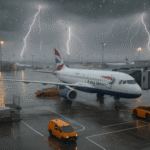
Thursday’s evening commute is expected to be particularly treacherous as heavy rainfall coincides with peak travel hours. Local authorities have coordinated with Metropolitan Transportation Authority (MTA) officials to monitor flooding at subway entrances and train lines.
Previous flash floods, including those during Hurricane Ida in 2021, demonstrated how quickly NYC’s transit infrastructure can become compromised. As a precaution, the Department of Environmental Protection is deploying crews to clear storm drains and distribute sandbags in critical areas.
National and Regional Context
The broader Northeast U.S. is also under weather advisories, with storm activity projected to affect areas from New Jersey to southern New England. The Federal Emergency Management Agency (FEMA) has been in contact with regional offices to prepare emergency response teams if flood conditions worsen.
Meanwhile, climate experts warn that the frequency and severity of such storms are increasing due to global climate change. New York City has already adopted a number of resiliency strategies, including improved stormwater management and waterfront defenses, but urban vulnerabilities remain.
What to Expect Next
The flood watch for New York City remains in effect through midday Friday, with rainfall expected to taper off by early afternoon. However, lingering high water levels and saturated grounds could still cause delays and disruptions into the weekend.
Meteorologists from the NWS will continue to monitor radar and weather model data closely and provide timely updates as the storm progresses.
Safety Tips from the National Weather Service
- Do not walk, swim, or drive through flood waters. Just six inches of fast-moving water can knock over an adult, and a foot of water can carry away most vehicles.
- Turn Around, Don’t Drown: A simple but life-saving message for anyone tempted to drive through flooded roads.
- Remain indoors during thunderstorm activity and avoid open spaces, tall objects, or water sources to reduce lightning strike risk.
Conclusion
As New York City faces the latest bout of extreme weather, the flood watch and associated travel advisory serve as critical reminders of the city’s vulnerability to flash floods. With preparedness, real-time updates from Notify NYC, and cooperation from residents, the city aims to minimize risk and ensure public safety throughout the storm’s impact.
For more travel news like this, keep reading Global Travel Wire