A powerful winter storm is preparing to sweep across the Southern United States and Northern Mexico this weekend. The event will bring a mix of freezing rain, sleet, and dangerous ice accumulations from January 23 to January 25, 2026. Travel disruptions are expected across major tourism hubs and transport corridors in Texas, Louisiana, Alabama, Georgia, North Carolina, and neighboring regions of Mexico.
This storm marks one of the most impactful January systems to target the Southern states in recent years. The event is being fueled by a collision between Arctic cold air and moisture from the Gulf of Mexico. This atmospheric clash will increase the risk of ice formation rather than snow, making travel conditions far more hazardous for tourists and residents.
Cold Air Meets Gulf Moisture
Meteorologists report that a shallow but dense Arctic air mass will surge south into the Central and Eastern U.S. at the same time a low-pressure system pulls warm, moisture-rich air inland from the Gulf. When the warm air overrides the cold layer at the surface, freezing rain becomes more likely than snowfall. This setup is known for creating treacherous ice storms.
In cities such as Dallas and Atlanta, temperatures are forecast to fall by more than 25 degrees within hours. Sudden temperature plunges of this scale are uncommon in the Deep South and often lead to flash freezing on roads, bridges, and elevated surfaces.
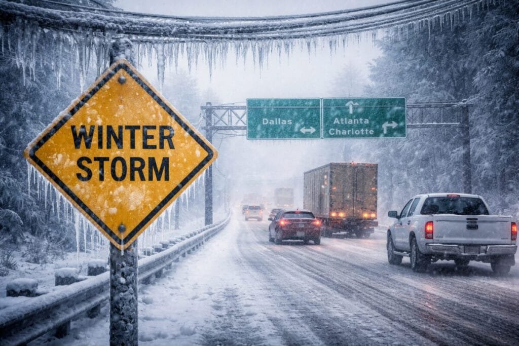
Key Travel Corridors at Risk
Popular interstate routes used by tourists and commercial travelers are expected to become difficult to navigate. The highest risk zones include:
I-20 Corridor
Running through Dallas, Shreveport, Jackson, Birmingham, and Atlanta, this corridor may see periods of freezing rain and widespread icing. Travel could become nearly impossible by late Friday.
I-30 Corridor
Dallas to Little Rock will face prolonged sleet and freezing rain. Tourism officials are warning drivers to reconsider weekend travel plans in this region.
I-40 Corridor
Memphis through central Tennessee and into North Carolina will experience wintry conditions, especially as the system shifts east on Sunday.
Even the more southern I-10 corridor, including Houston and Lake Charles, may encounter black ice overnight as temperatures sink below freezing.
Air Travel Disruption Expected
Tourism and aviation analysts expect substantial air travel delays at several major airports that serve as national and international hubs.
Dallas/Fort Worth International Airport
One of the world’s busiest airports is likely to face cancellations as ice accumulates on runways and aircraft surfaces. Ground stops could begin late Friday.
Hartsfield-Jackson Atlanta International Airport
Atlanta is a key gateway for domestic tourism and international transit. Freezing rain may lead to long delays Saturday into Sunday.
Charlotte Douglas International Airport
Charlotte may experience freezing rain on Sunday, which can slow de-icing operations and restrict runway use more than snowfall would.
Travelers connecting through these hubs should expect delays, missed connections, and schedule changes.
Ice Accumulation: The Biggest Threat
Unlike snow, freezing rain creates clear sheets of ice that weigh down power lines and snap tree branches. Weather models suggest:
- A high probability of at least 0.25 inches of ice across parts of Alabama and Georgia
- The possibility of up to 1 inch in localized areas
Only a quarter-inch of ice can add hundreds of pounds to tree limbs and power infrastructure. Widespread outages may occur, especially in rural regions that rely on exposed power lines.
Tourism & Traveler Safety Guidance
Local authorities and emergency managers recommend that weekend travelers:
- Complete travel by Friday afternoon
- Monitor local alerts
- Pack winter emergency kits
- Prepare for possible power outages
Visitors booked for weekend events, sports travel, or holiday tourism may need to adjust plans. Hotel bookings may increase as travelers seek to avoid driving in icy conditions, especially along major highway exits.
Storm Alerts Issued for Major Cities
As of January 21, 2026, winter storm watches and special weather statements are active in:
- Dallas–Fort Worth, Texas
- Houston, Texas
- Shreveport, Louisiana
- Birmingham, Alabama
- Atlanta, Georgia
- Charlotte, North Carolina
Northern Mexico is also preparing for frigid temperatures across border states, though direct ice impacts will be more limited.
Tourism Outlook and Final Assessment
This storm arrives at a time of growing winter tourism across southern states that usually enjoy milder weather. The upcoming weekend’s storm may temporarily interrupt:
- Winter festivals
- Outdoor sightseeing
- Regional sports tourism
- Road trip itineraries
- Airport transit tourism
Travel analysts agree that the combination of freezing rain, road ice, and airport delays creates a high-risk travel period through Sunday. Visitors and residents are encouraged to stay informed, adjust travel schedules, and exercise caution until conditions improve.
For more travel news like this, keep reading Global Travel Wire