A powerful Arctic cold snap is sweeping across the United States, creating widespread travel challenges across Vermont, Michigan, Pennsylvania, Ohio, Indiana, and New Hampshire. The extreme weather is expected to bring severe cold, strong winds, snow, and ice, turning this weekend into one of the most difficult travel periods of the winter season.
Authorities warn that freezing temperatures and hazardous conditions may cause extensive flight delays, road closures, and disruptions to tourism activities across major cities and popular destinations.
Arctic Blast Pushes Temperatures to Dangerous Levels
Meteorologists predict that an intense surge of Arctic air moving south from Canada will drive temperatures far below seasonal averages. Many areas across the Northeast and Midwest will experience wind chills well below zero, creating dangerous conditions for travelers.
The sudden drop in temperature is expected to arrive quickly, with snow showers and strong winds developing late Friday. These conditions may create rapid freeze-ups on highways, sidewalks, and airport runways.
Officials advise residents and visitors to monitor forecasts closely and prepare for severe cold exposure risks such as frostbite and hypothermia.
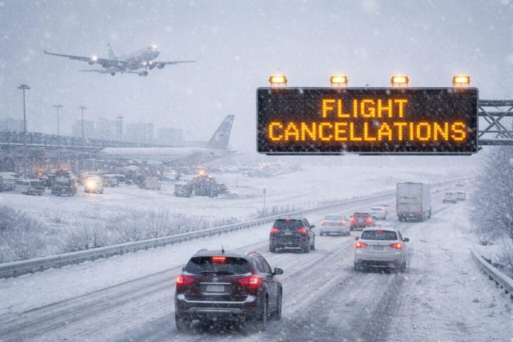
Major Travel Disruptions Expected Across Northeast States
Airlines and transportation agencies are already warning passengers to anticipate delays and cancellations. Airports in key hubs including New York, Boston, Detroit, and Philadelphia are likely to face operational challenges due to icy conditions and reduced visibility.
Heavy snow combined with freezing rain may make runways difficult to maintain. Airlines typically reduce flight schedules during extreme weather to ensure safety. As a result, thousands of passengers may face last-minute itinerary changes.
Rail services and bus routes may also experience disruptions, while local public transport could run on limited schedules in affected cities.
Snow and Ice Create Hazardous Road Conditions
Driving conditions across the Great Lakes region and the Appalachian corridor are expected to worsen as temperatures drop. Even light snowfall can quickly turn into dangerous ice when combined with freezing temperatures.
Transportation departments urge drivers to avoid unnecessary travel during peak storm periods. Strong winds may create blowing snow and sudden whiteout conditions, reducing visibility on highways.
Emergency teams recommend carrying winter survival kits in vehicles, including blankets, water, and charged mobile devices. Reduced traction and slippery roads increase accident risks, especially during nighttime temperature drops.
Tourism Industry Faces Weekend Slowdown
The extreme weather event is likely to impact tourism across several popular destinations. Cities such as New York, Boston, and Chicago usually attract significant winter visitors, but harsh conditions may reduce visitor numbers temporarily.
Hotel bookings and event attendance may decline as travelers postpone trips or cancel plans. Outdoor attractions, winter festivals, and sightseeing tours could operate with restrictions due to safety concerns.
Tour operators often adjust schedules during severe weather, and travelers are encouraged to confirm reservations in advance.
Wind Gusts and Extreme Cold Raise Safety Concerns
Wind gusts reaching up to 50–55 mph may worsen the cold conditions by creating dangerously low wind chill values. Exposure to such temperatures for extended periods can quickly become life-threatening.
Health officials recommend limiting outdoor activities, wearing layered clothing, and covering exposed skin. Travelers unfamiliar with harsh winter climates should take extra precautions, as extreme cold can impact both physical safety and transportation reliability.
Power outages remain a potential risk if ice accumulates on power lines or strong winds cause infrastructure damage.
Why This Arctic Front Is So Severe
Weather experts attribute the event to a strong Arctic air mass moving southward due to shifting atmospheric patterns. When cold air interacts with existing moisture systems over the Great Lakes and Northeast, it creates snow bands and icy precipitation.
These systems often produce localized heavy snowfall and sudden temperature drops, which make forecasting travel conditions more complex. Rapid weather changes can catch travelers off guard, especially during busy weekend travel periods.
Travel Safety Tips for Visitors and Residents
Authorities urge travelers to stay prepared and flexible. Key safety recommendations include:
- Check flight status regularly before heading to airports.
- Allow extra travel time due to weather delays.
- Dress in insulated layers and wear waterproof footwear.
- Keep emergency supplies when driving long distances.
- Avoid non-essential travel during peak storm hours.
Following official weather updates and transportation alerts can help minimize risks during the cold snap.
Outlook: One of the Coldest Weekends of the Season
Forecasters expect this Arctic blast to create some of the coldest conditions of the winter so far. Sub-zero wind chills, icy roads, and heavy snow could continue into Sunday before temperatures slowly recover.
While winter storms are common in the region, the combination of intense cold and widespread ice makes this event particularly challenging for travel and tourism.
Travelers planning trips across the Northeast and Midwest should remain cautious, flexible, and prepared for sudden changes. With proper planning and awareness, the risks associated with this severe weather event can be reduced.
For more travel news like this, keep reading Global Travel Wire