A powerful spring winter storm is set to impact large areas of the western United States, bringing heavy snow, strong winds, freezing temperatures, and dangerous road conditions. Official weather alerts indicate that mountain regions, national parks, and key travel corridors may experience rapid deterioration in conditions from Wednesday through Friday.
For travelers, this storm could significantly affect scenic drives, ski trips, national park visits, and interstate road journeys. Some locations may receive up to 18 inches of snow, while exposed ridges could face severe wind gusts strong enough to reduce visibility and create near-whiteout conditions.
Authorities are urging residents and visitors to monitor local forecasts, delay unnecessary travel where possible, and prepare for sudden closures or hazardous driving conditions.
Why This Storm Matters for Tourism
The western United States is home to some of the country’s most iconic outdoor destinations. Mountain highways, park entrances, ski areas, and scenic byways attract millions of visitors every year.
When heavy snow arrives across multiple states at once, tourism can be affected in several ways:
- Highway delays and closures
- National park access restrictions
- Flight and airport disruptions
- Reduced visibility for road trips
- Hotel schedule changes
- Outdoor activity cancellations
Even spring storms can be severe at higher elevations, especially in mountainous states where weather can change quickly.
Areas Forecast to Receive the Heaviest Snowfall
Official forecasts indicate the strongest snowfall totals are likely in higher terrain across several western states.
Montana and Wyoming
Mountain ranges in Montana and Wyoming, including the Absaroka and Beartooth regions, could receive up to 18 inches of snow. Winds may reach 60 mph in exposed areas, increasing drifting snow and reducing visibility.
Additional ranges such as Gallatin, Madison, and Centennial areas may receive between 5 and 12 inches.
Yellowstone Region
Yellowstone National Park and surrounding mountain zones, including the Teton and Gros Ventre areas, are also expected to see significant snowfall. Higher elevations are likely to experience the largest accumulations.
Travelers planning wildlife tours, spring vacations, or scenic drives should prepare for changing access conditions.
Idaho and Mountain Passes
Parts of Idaho may see snowfall ranging from valley accumulations to heavier totals at higher elevations. Routes near Lost Trail Pass and Lemhi Pass could become difficult, especially with gusty winds and icy surfaces.
California and Nevada
In the Sierra Nevada of California and Nevada, totals may vary sharply by elevation. Some lower areas could see light snow, while higher peaks may receive up to 18 inches.
The Lake Tahoe region may also experience strong ridge-top winds and changing road conditions.
Oregon and Washington
Mountain areas in Oregon and Washington are forecast to receive moderate to heavy snowfall, with higher elevations facing the greatest impacts.
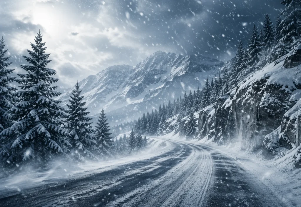
Travel Conditions Could Become Dangerous
Officials warn that some routes may become extremely hazardous, especially over mountain passes and exposed highways.
Key risks include:
- Snow-covered roads
- Blowing snow reducing visibility
- Black ice formation
- Strong crosswinds
- Falling tree limbs
- Temporary road closures
In mountain regions, conditions can worsen within hours. A road that is wet in the morning may become snow-packed and icy by afternoon or evening.
Drivers should be prepared for chain requirements, slower speeds, and rapidly changing weather.
National Parks and Scenic Areas Could See Disruptions
Spring is a popular time for travelers visiting western parks, but weather can still create winter-like conditions.
Areas near Glacier National Park may face blowing snow and limited visibility, especially near high passes such as Marias Pass.
Visitors planning trips to Yellowstone, Grand Teton, or mountain recreation zones should check park alerts, road status reports, and weather updates before departure.
Trail access, ranger programs, and visitor services may also be affected depending on local conditions.
Additional Weather Threats Beyond Snow
The storm is not limited to snowfall. Strong winds across several states could lead to power outages and travel delays.
In parts of Utah, freezing overnight temperatures are also expected. Agricultural areas and valley communities may experience subfreezing conditions that can affect crops, gardens, and outdoor plumbing.
This combination of snow, wind, and freezing temperatures makes the event more disruptive than a typical spring weather system.
Essential Travel Advice for Visitors
If travel cannot be postponed, preparation is critical.
Smart Travel Tips
- Check road conditions before departure
- Carry tire chains where required
- Keep emergency supplies in your vehicle
- Charge mobile devices fully
- Allow extra travel time
- Monitor weather alerts frequently
- Avoid night driving in mountain zones
Travelers with hotel or tour bookings should also confirm cancellation policies and operating schedules.
Frequently Asked Questions
Which states are most affected?
Montana, Wyoming, Idaho, California, Nevada, Oregon, Washington, and Utah are among the areas facing impacts.
Could travel become impossible?
Yes. Some mountain roads and passes may become temporarily unsafe or inaccessible.
Are national parks open?
Many parks remain open, but roads and services may change depending on local weather.
How long will the storm last?
Main impacts are expected from Wednesday into Thursday, with some areas seeing lingering effects into Friday.
Final Takeaway
This Western US snowstorm is a major travel event for tourists and residents alike. With up to 18 inches of snow, powerful winds, and freezing temperatures forecast across popular destinations, travelers should plan carefully and stay updated. From Yellowstone to Lake Tahoe, spring adventures may briefly turn into winter challenges—but smart preparation can make all the difference.